New Google map features now onthe CTBTO website
The public website of the Preparatory Commission for the Comprehensive Nuclear-Test-Ban Treaty Organization (CTBTO) now displays timelines on the history of nuclear testing, the history of the Treaty adherence, and the history of the build-up of the global alarm system designed to detect all nuclear explosions on Earth. And it includes many other interactive features. View the the new maps here!
Historical insights
A timeline placed at the bottom of the map on CTBT adherence offers glimpses into the history of the Treaty and the CTBTO. By clicking anywhere on the timeline, the map displays the exact status of signatures and ratification at that moment in history. It also shows the annual breakdown of signatures and ratifications at the beginning of every year.
In a separate line labeled “key dates”, the timeline marks historically significant events, such as the establishment of the CTBTO’s Vienna office in March 1997, the nuclear tests conducted by India and Pakistan in May 1998, the rejection of CTBT ratification by the US Senate in October 1999 and the two nuclear tests conducted by North Korea in 2006 and 2009. Links guide the reader to related stories on the CTBTO website for in-depth information.

New interactive maps offer glimpses into the history of the Treaty and the CTBTO.
The colour scheme of the map has been improved so that a State’s Treaty status is now clearly visualized, with non-signatories States marked in red.
The map also allows for the enlargement of two regions – the Caribbean and Europe. More clicks in the new view increase the zoom even further. This provides a better overview of the status of signatures and ratifications of States in the respective area, in particular the smaller ones.
Information on Treaty status
This map also allows the user to acquire concrete information on the Treaty status of a particular State. A scroll over any State opens a box with the dates of its signature and ratification. It also shows whether the respective country is an Annex 2 State, i.e. one of those countries whose ratification is needed for the Treaty’s entry into force.

The colour scheme of the map has been improved.
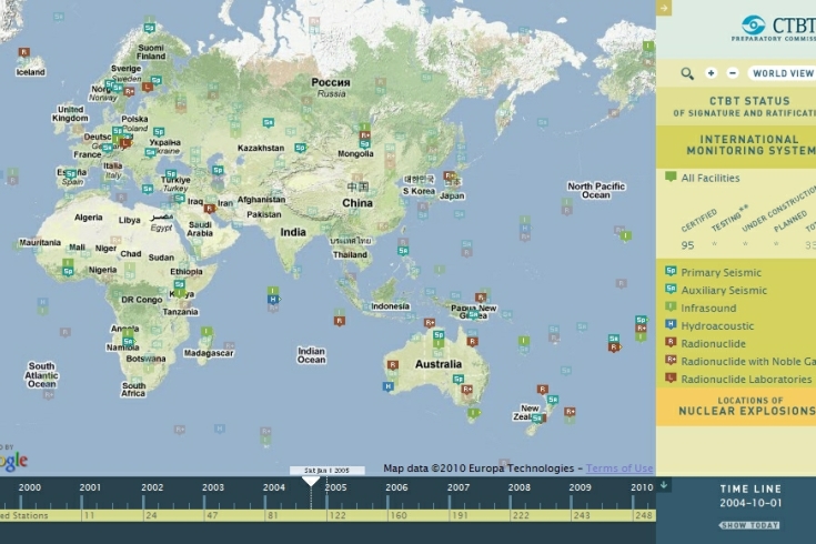
A timeline at the bottom of the International Monitoring System (IMS) map on the offers insights into the history of its build-up. Clicking anywhere on the timeline shows those monitoring facilities in full colour that had been certified at that time. Planned stations that had not yet been built appear in an opaque colour. Scrolling over any station displays its name along with the certification date marked in the timeline.
In addition, the IMS map can be used to inquire about the status of monitoring stations of a particular technology. As before, this feature goes beyond depicting the four technologies – i.e. seismic, hydroacoustic, infrasound and radionuclide. The seismic stations are divided into primary seismic stations, which send monitoring data continuously, and auxiliary seismic stations, which send data on demand. Radionuclide stations with noble gas technology are depicted with a plus sign. In each of these sub-views, the timeline helps to visualize the progress made in the build-up of a particular technology network.

In October 2004 nearly 100 IMS stations were certified.
The map on the locations of nuclear explosions also includes a timeline with information on the nuclear explosions conducted in any given year. This includes the total number of nuclear explosions, the accumulated number of nuclear explosions until that year, a breakdown by State and a graphic depiction of the type of nuclear explosion conducted.
Clicking on key dates will link users to information about milestone events in the history of nuclear testing such as the dropping of nuclear bombs over Hiroshima and Nagasaki in August 1945, the call by India’s Prime Minister Nehru in 1954 for a stand-still agreement on nuclear testing or the signature of the Partial Test Ban Treaty in 1963.
Further enhancements to come
Any of the maps can be viewed in full-screen mode by hiding both the bottom timeline and the right-hand legend/navigation bar. Should you not be able to see the new map, please make sure to refresh your browser's cache by holding down the SHIFT key and clicking the refresh button in your browser. This will clear the cache and you will see the new map.
Visitors to the CTBTO website can expect to see more interactive features in the course of the year. There will also be further enhancements of functions and features that already exist. We will keep you updated!

The map on the locations of nuclear explosions also provides additional information.
