
On the CTBTO's detection in North Korea
Vienna, 12 February 2013
At 2.57.51 this morning (UTC), monitoring stations of the Preparatory Commission for the Comprehensive Nuclear-Test-Ban Treaty Organization (CTBTO) detected a seismic event with explosion-like characteristics in the Democratic People’s Republic of Korea (DPRK).
The CTBTO’s first and preliminary automatic detections were made by up to 25 seismic stations around the world. The first data were made available to CTBTO Member States in little more than one hour, and before the DPRK’s announcement.
The event measured 5.0 in magnitude, which is around twice as large as the DPRK’s nuclear test in 2009 (4.52) and much larger than the one in 2006 (4.1). The location accuracy is currently approximately +/- 16.2 kilometres, indicating that the location of today’s event is largely identical with the two previous nuclear tests (Lat.: 41.313 degrees north; long.: 129.101 degrees east). As with the two previous nuclear tests, the signal was emitted from close to the surface.
As data from further stations is analyzed, both automatically and by analysts, more precise information on the event’s location, time, depth and magnitude will become available.
The CTBTO is the international organization responsible for ensuring that no nuclear explosion goes undetected. Its verification technologies include seismic sensors that record shockwaves in the ground caused by underground nuclear explosions. The 2006 DPRK nuclear test was detected by 22 seismic stations, the 2009 test by 61. This increase was due to the rise in the number of operational stations as well as the larger magnitude of the 2009 test. Between 2009 and February 2013, the number of CTBTO seismic stations has further increased from 130 to 160. In total, over 85 percent of the CTBTO’s 337 monitoring facilities are now up and running; see interactive map.
The DPRK’s action was strongly condemned by Tibor Tóth, the Executive Secretary of the CTBTO, and by Jan Petersen, Chairman of the CTBTO’s executive body.
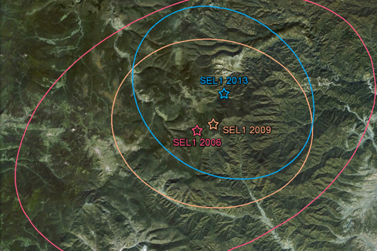
Comparison of the first automatic location estimates of the 2006, 2009 and 2013 declared nuclear tests by North Korea - click to enlarge.

Naturally occurring seismicity in North Korea is low. This map shows the earthquakes since 2005 - click to enlarge.

These seismic stations were the first to send data about the event; others will follow - click to enlarge.
For further information on the CTBT, please see www.ctbto.org – your resource on ending nuclear testing,
or contact: Annika Thunborg,
Spokesperson and Chief, Public Information T +43 1 26030-6375
E [email protected]
M +43 699 1459 6375
I www.ctbto.org Connect with CTBTO on facebook, twitter, flickr and youtube.
or contact: Annika Thunborg,
Spokesperson and Chief, Public Information T +43 1 26030-6375
E [email protected]
M +43 699 1459 6375
I www.ctbto.org Connect with CTBTO on facebook, twitter, flickr and youtube.